![]()
| Search | Back Issues | Author Index | Title Index | Contents |
|
D-Lib Magazine |
 |
 |
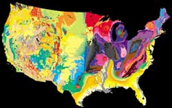
This component of the tapestry is simplified from the geologic map of King and Beikman (1974). Courtesy of the United States Geological Survey. Used with permission. |
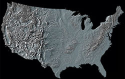
This component of the tapestry is the digital shaded-relief image, created by Thelin and Pike (1991). Courtesy of the United States Geological Survey. Used with permission. |
Fittingly titled, "A Tapestry of Time and Terrain," the map weaves together, in vivid colors and shadings, the topographical and geological components of the lower 48 states. This union of topographic texture with the patterns defined by units of geologic time creates a visual synthesis that has escaped most prior attempts to combine shaded relief with a second characteristic shown by color.
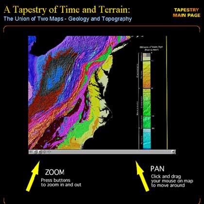
Image captured while using the Tapestry of Time and Terrain panorama movie. Panorama movie courtesy of the United States Geological Survey. Used with permission. |
Features of the Tapestry of Time and Terrain web site include an interactive puzzle of geographic regions, and an interactive panorama movie. The image above was created from a screen capture while using the panorama movie. (The movie requires the QuickTime plug-in, which can be downloaded at no charge.)
This web site corresponds to the USGS printed product Geologic Investigations Series I-2720. PDF files of the Tapestry map are available for download. The Tapestry of Time and Terrain map is available also as a 58"x42" poster. For a copy of the printed poster and accompanying pamphlet, contact:
USGS Information Services, Map Distribution
Box 25286
Denver Federal Center
Denver, CO 80225
tel: 303-202-4210
The Tapestry of Time and Terrain web site is located at <http://tapestry.usgs.gov>.
The USGS production team who created the maps and other information on the Tapestry of Time and Terrain web site include: Joe Vigil, David G. Howell, Richard J. Pike, Eleanore Jewel, and Naomi Kalman.
Courtesy of:
Kate E. Barton
Webmaster, Tapestry of Time and Terrain web site
United States Geological Survey
DOI: 10.1045/june2001-featured.collection