
Un géorépertoire
personnalisable
sur Internet pour les données spatiales
 |
L.J. Casault Pavilion, Suite 0609 Laval University Quebec, Canada G1K 7P4 [email protected] |

The goal of this paper is to present GEOREP (http://sirs.scg.ulaval.ca), a prototype of a WWW customizable Georeferenced Digital Library (GDL) for spatial data. This research project addresses three main issues: georeferenced digital library accessible on the internet, customizable content and querying and more specifically spatial information retrieval. The innovative characteristics of GEOREP is the high customizability which, for example, provides users the possibility to choose different levels of detail (e.g. data set vs map sheet, small vs large number of metadata (1)) and different metadata standards. This characteristic applies to the content of GEOREP as well as the querying front-end and the resulting output. This GEOREP prototype follows a more complete R&D project that we made for the development of a commercial GDL (Geoscope Network II) by the private industry. However, GEOREP per se was developed with very limited resources, that is seven months-person, half of it by an undergraduate student in geomatics.
The particular design of the GEOREP
prototype facilitates its maintenance as it eliminates the update
operations of the web pages when adding or deleting documents.
All changes made in the database directly appear in the query
results. In the next version, this interactivity will be extended
to the updating of the database through the Internet.
Table of contents:
For the last seven years, at the
Center for Research in Geomatics we have been involved in Georeferenced
Digital Libraries (GDLs). For example, we developed a metadata
acquisition tool, single-user GDLs on MapInfo and Intergraph MGE;
we extended the idea for business reengineering, and we made tests
with five organizations. In the last months, we have been involved
in the design of a commercial GDL for the private industry. Afterwards,
we decided to go beyond this project and build a WWW GDL for our
own internal use and also to have a teaching and research tool.
After a detailed analysis of 24 existing WWW GDLs and
of our past experiences, we defined the desired characteristics
of GEOREP. The next sections give an overview of this project.
We begin with a presentation of the characteristics which make
this site a unique GDL, then we describe GEOREP into more details
and conclude with future developments. More detailed information
can be obtained by a visit to the GEOREP web site).
2. Comparison with similar
projects:
In many ways, the GEOREP prototype is
similar to well known digital
library projects such as: Alexandria Digital Library
(University of Santa Barbara, California), Digital Library
Project
(University of Berkeley), Distributed Spatial
Data Library
(ERIN, Australia) and Land Data BC
(Ministry of Environment, Lands and Parks, BC, Canada).
Thus, the main objectives of this research
project are as those of the projects listed above, namely:
In spite of several similarities, this project also differs from the others on some aspects, making the combined result unique in the world of GDLs. The characteristics described below are specific to the GEOREP or are an extension of features developed in similar projects.
The version of GEOREP presently running
at http://sirs.scg.ulaval.ca is version 1.0. This version consists
of the traditional read-only query front-end which uses both graphics
and tabular data (updates being made by the system administrator
directly in the server database). This is the version described
in the present paper. Version 2.0 is due for December 1996,
it will add read-write access to the database by means of customizable
fill-in forms supporting metadata entry by the user directly on
the Web. It will also add improved user interface and graphical
display of query results. Thus, in addition to the innovations
previously presented, the development of version 2.0 addresses
new challenges:
3. Description of the GEOREP
prototype used for the Forêt Montmorency area:
The area used for this prototype is
the university-owned "Forêt Montmorency" which
is an experimental site in the "Laurentides" Provincial
Park located 70 km North of Quebec City. The choice of this site
for the prototype was made because of the large quantity and diversity
of documents produced over the years by researchers of different
organizations, thus offering an excellent test area while at the
same time an immediately useful GDL. These documents include topographic
maps, forest cover maps, aerial photographs, airborne and satellite
remote sensing images, multimedia documents such as videos, photographs,
slides, etc. These documents are very heterogeneous with regard
to their scales, content, quality, sources, format, etc. For practical
reasons, the metadata model implemented into version 1.0 is a
subset (90 metadata) of the complete 458-attribute metadata model
built for the soon-to-be released commercial product Geoscope
Network II.
Using the prototype implies several
operations which can be summed up in figure 1. The user starts the prototype through the Java
application to define the area of interest within the whole area
covered by Forêt Montmorency. Then, the user can customize
his environment step-by-step; for example, he can select
the metadata standard to be used to build the query form (step
A). Then the user builds his query to extract the documents that
satisfy his given criteria (step B) to finally read the result
of the query (step C). The user can analyse this first result
and refine his query to obtain more specific details about particular
documents (step D). Finally, the user can view a graphic sample
of this document and the area of the Forêt Montmorency it
covers (step E).

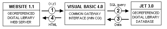
The internal process of GEOREP is illustrated
in figure 2. The server receives the coordinates of the area of
interest and sends them to the corresponding CGI (step 1). It
can be the area defined by the user or the default area identified
for the prototype. Then the server receives the specific criteria
expressed in the query form and activates the corresponding CGI
to query the database within the previously-defined area and the
given criteria (step 2). The database engine runs the SQL query
to select all documents that satisfy the criteria and returns
all desired metadata to the CGI (step 3). The CGI sends the HTML
code to the server to then display the result of the query on
the user site (step 4). To further refine queries and for graphic
displays (cf. step D and E, figure 1) the server remakes all the
process according to the additional criteria. However, for step
E (cf. figure 1), the CGI writes the coordinates of the area covered
by the document into a text file. These coordinates will be used
in the version 2.0 to draw the area covered by the document on
the map of the Java-built graphical interface.
A prototype of GEOREP version 1.0 is now implemented for the management of the georeferenced documents used at Forêt Montmorency. Version 2.0 should be available by the end of December 1996. Afterwards, more improvements will be needed and should be developed during 1997; these improvements will include multi-scales and non-rectangular coverages and spatial querying, nicer user-interface, order forms with billing capabilities, and ISO metadata standards. Professors, students and professionals are invited to use the prototype and send us their comments about this site. It will help us to improve the prototype and to gather new ideas for future versions of GEOREP. For those who are interested, a more complete document can be obtained from the authors.
5. Notes
(1)
This
is the information that describes the dataset (e.g. official name,
owner, data updating, aerial coverage).
(2) Standard Survey for Collecting Directory Information describing Digital Geo-referenced Data sets, Canadian General Standards Board, on March 3th 1994.
(3) Content Standards for Digital Geospatial Metadata, Federal Geographic Data Committee, on June 8th 1994


hdl:cnri.dlib/december96-proulx